Star-Spangled City
Why this matters: new research or scientific developments with potential real-world impact.
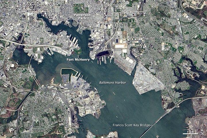
Earth Observatory Science Earth Observatory Star-Spangled City Earth Earth Observatory Image of the Day EO Explorer Topics All Topics Atmosphere Land Heat & Radiation Life on Earth Human Dimensions Natural Events Oceans Remote Sensing Technology Snow & Ice Water More Content Collections Global Maps World of Change Articles Earth Matters Blog Blue Marble: Next Generation EO Kids Mission: Biomes About About Us Subscribe 🛜 RSS Contact Us Search April 24, 2014 Editor’s note: In honor of America’s 250th birthday, Earth Observatory is revisiting stories about the landscapes that helped shape U.S. history. The images and text on this page were originally published on September 14, 2014. Explore the full collection here. The song is familiar to every American, but the moment and place where it was composed are less so. On April 24, 2014, the Operational Land Imager (OLI) on Landsat 8 captured this view of Baltimore, Maryland, and its harbor. Fort McHenry and its star-shaped ramparts—the place where “that star-spangled banner yet wave[d],” on September 14, 1814—stand at the entrance to the city’s Inner Harbor. The area was a pivotal battleground in the War of 1812. In September 1814, British naval and ground forces advanced on the city of Baltimore, emboldened by the August 24 burning of the White House and the Capitol building in Washington, D.C. On September 12, British forces landed at North Point, 5 miles (8 kilometers) southeast of Baltimore (just off the lower right of this image), and engaged American troops in several small battles. By September 13, the land forces approached the city of Baltimore but were repelled by U.S. Army and Maryland militia forces assembled behind a mile of earthworks and trenches along Hampstead Hill—near what is now known as Patterson Park (image top center). On the morning of September 13, British naval vessels set up positions roughly at the point where this image is labeled Baltimore Harbor. They began a 25-hour bombardment of