Why Venezuela's earthquake was so deadly: shallow, powerful and just seconds apart
Key takeaways
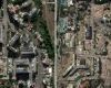
- The satellite images that have gradually emerged confirm a trail of collapsed buildings along the coast, the most densely populated and hardest-hit area.
- The first tremor, of magnitude 7.2, had its epicenter in Yaracuy state, west of La Guaira and Caracas.
- The destruction followed the line of the San Sebasti n fault, running parallel to the coast, at the boundary between the Caribbean and South American plates.
Why this matters: an international story with cross-border implications worth tracking.
The combination of two powerful, very shallow earthquakes just 39 seconds apart explains much of the devastation left by Wednesday's earthquake in north-central Venezuela, where the latest official toll exceeds 1,450 dead and 3,150 injured. The satellite images that have gradually emerged confirm a trail of collapsed buildings along the coast, the most densely populated and hardest-hit area.
The first tremor, of magnitude 7.2, had its epicenter in Yaracuy state, west of La Guaira and Caracas. The second, 39 seconds later and of magnitude 7.5, released almost three times more energy than the first, according to the US Geological Survey. Both occurred at a shallow depth —the main one at about ten kilometers— a decisive factor in the scale of the surface damage. Not only was the energy high, but they were also very shallow, especially the second, which is devastating, Miguel ngel Rodr guez Pascua, of Spain's Geological and Mining Institute, told EL PA S. Another element worsened the consequences: because the two quakes occurred within less than a minute, many people did not have time to evacuate their buildings between one and the other.
The destruction followed the line of the San Sebasti n fault, running parallel to the coast, at the boundary between the Caribbean and South American plates. Images from companies such as Vantor and Planet Labs show collapsed apartment towers and resorts in the coastal towns of Catia La Mar, Macuto and Caraballeda, the latter one of the worst affected. The collapse of a twelve-story building in Caraballeda has become one of the symbols of the tragedy. A preliminary analysis by Oregon State University, based on European satellite data, estimated that close to 58,900 buildings were damaged or destroyed.