top
Iran nuclear and military damage revealed after restricted satellite images released
Key takeaways
- A leading satellite imagery provider, Planet Labs, restored access to images from nearly 800 locations in Iran which they had chosen to restrict following a request from the US government.
- BBC Verify analysed satellite imagery from two key locations - Esfahan and Bushehr - captured since restrictions began on 9 March.
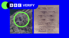
- The images show a variety of targets hit from ammunition storage areas to ballistic missile infrastructure, nuclear and surface-to-air missile sites, and naval bases, according to military intelligence company Janes.
Why this matters: a developing story that could shape the day's news cycle.
Thomas, Barbara Metzler, Benedict Garman and Alex Murray Published39 minutes ago The extent of damage to some of Iran's military and nuclear sites has been revealed for the first time after more than a quarter of a million previously restricted high-resolution satellite images were released.
A leading satellite imagery provider, Planet Labs, restored access to images from nearly 800 locations in Iran which they had chosen to restrict following a request from the US government.
BBC Verify analysed satellite imagery from two key locations - Esfahan and Bushehr - captured since restrictions began on 9 March.
Article preview — originally published by BBC News. Full story at the source.
Read full story on BBC News →
More top stories
Also covered by
Aggregated and edited by the Scoop newsroom. We surface news from BBC News alongside other reporting so you can compare coverage in one place.
Editorial policy · Corrections · About Scoop