Digging Back in Time in the UAE
Why this matters: new research or scientific developments with potential real-world impact.
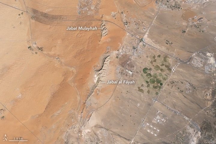
Earth Observatory Science Earth Observatory Digging Back in Time in the UAE Earth Earth Observatory Image of the Day EO Explorer Topics All Topics Atmosphere Land Heat & Radiation Life on Earth Human Dimensions Natural Events Oceans Remote Sensing Technology Snow & Ice Water More Content Collections Global Maps World of Change Articles Earth Matters Blog Blue Marble: Next Generation EO Kids Mission: Biomes About About Us Subscribe 🛜 RSS Contact Us Search Jabal al Fāyah rises from the Rub’ al Khali desert in an image captured by the OLI (Operational Land Imager) on Landsat 8 on October 23, 2025. NASA Earth Observatory / Lauren Dauphin About an hour’s drive east of Dubai’s gleaming towers and artificial islands, a quieter, more natural landscape takes shape. At the far northern edge of the Rub’ al Khali, a saffron-colored sand sea laps against the Al-Hajar Mountains. A series of pale ridges rises finlike from the desert plain, with the largest—Jabal al Fāyah—standing 412 meters (1,352 feet) above sea level. The Landsat 8 satellite captured this image of the ridges cutting across the Emirate of Sharjah in the northern part of the United Arab Emirates on October 23, 2025. To geologists, the limestone ridges are a reminder of the region’s watery past, signs that this land lay underwater tens of millions of years ago when the sedimentary rock layers were deposited. Jabal al Fāyah functions as a barrier, trapping windblown sand in dune fields to its west. The weathering of iron-bearing minerals in the sand grains gives the dune fields their orange hue. To the east, the branching channels of overlapping alluvial fans extending from the Al-Hajar Mountains carry gravels and eroded sediments from basalts and other dark mafic rocks. The dark rocks to the east—part of the Samail Ophiolite—are known to geologists for being among the world’s largest, best-preserved, and most accessible exposures of ancient oceanic lithosphere, the rigid outer layer of Earth that include