Gravity Waves From Super Typhoon Sinlaku
Why this matters: new research or scientific developments with potential real-world impact.
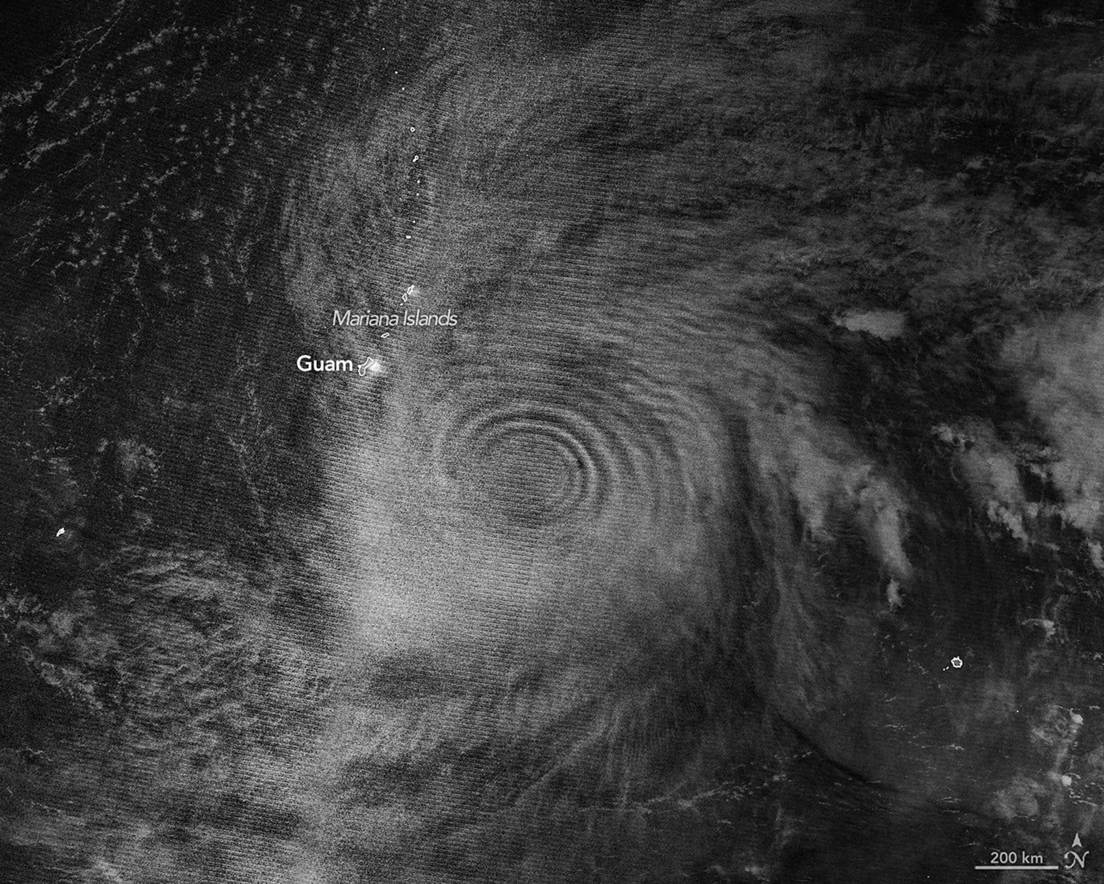
Earth Observatory Science Earth Observatory Gravity Waves From Super… Earth Earth Observatory Image of the Day EO Explorer Topics All Topics Atmosphere Land Heat & Radiation Life on Earth Human Dimensions Natural Events Oceans Remote Sensing Technology Snow & Ice Water More Content Collections Global Maps World of Change Articles Notes from the Field Blog Earth Matters Blog Blue Marble: Next Generation EO Kids Mission: Biomes About About Us Subscribe 🛜 RSS Contact Us Search Atmospheric gravity waves generated by Super Typhoon Sinlaku are visible via mesospheric airglow in this nighttime image acquired with the VIIRS (Visible Infrared Imaging Radiometer Suite) on the NOAA-20 satellite on April 12, 2026, Universal Time (April 13 local time). NASA Earth Observatory/Michala Garrison In mid-April 2026, Super Typhoon Sinlaku churned across the North Pacific Ocean and brought heavy rain and flooding to the Mariana Islands. The storm reached “violent typhoon” status—the highest intensity on the scale used by the Japan Meteorological Agency and roughly equivalent to a category 5 storm on the Saffir-Simpson wind scale. Sinlaku was one of only a handful of tropical cyclones of that intensity known to have occurred so early in the year in the region, meteorologists noted. Sinlaku rapidly intensified over the ocean before its impacts reached land. Around the time of this strengthening, satellites began to detect that the typhoon’s effects also extended upward, into the upper atmosphere. The nighttime image above, acquired with the VIIRS (Visible Infrared Imaging Radiometer Suite) on the NOAA-20 satellite, shows atmospheric gravity waves radiating from the typhoon. These waves, resembling ripples on a pond, were made visible to the sensor via airglow in the mesosphere. Airglow occurs when atoms and molecules, excited by sunlight during the day, later emit light to release excess energy. The release of latent heat near the eyewalls of tropical cyclones is known to drive